
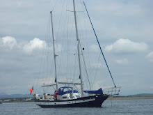
Soon after waking up we realised it wouldn’t be possible to continue our voyage due to the rough water across the North Channel. We were informed that our exposed position here at Balleycastle meant that gale force 8 in the Atlantic resulted in heavy seas here in the channel making it unsafe to head towards our destination. As we were stranded for the day we took the opportunity to bake some bread. We distributed the dough and each of us shaped our own roll to accompany the potato and leek soup Mary had been making. The shapes certainly turned out to be interesting ranging from Akanksha’s plait, Melissa’s Hedgehog and Lucy and Zuleikha’s Rastafarians!
After a filling lunch we decided to work on our navigation skills. In pairs we learnt how to plot points and locate positions on a sea chart using points of latitude and longitude to the nearest minute aswell as calculating distances in nautical miles. It was important to acknowledge how useful this would be in an emergency situation. We were also shown how to determine our own location if we had the compass bearing of two or more navigational sites. After successfully demonstrating our newly acquired skills on the chart, Port were delighted to realise they would know be able to navigate themselves to New York!
After quick showers, we all sat down and assessed our current food situation. Geared with a carefully planned shopping list we head out into town in search of the nearest grocery store. To our dismay it had started to rain and hence seven of us had to make the walk back to the boat with shopping bags dripping wet. It was ironic that we found ourselves drenched without even setting sail into the raging sea, If only we had worn our trusted waterproofs! Helen chose to stay behind and prepare her speciality dish - bratkatoffeln (German fried potatoes).
We ended this comparatively relaxed day with a big game of bananagrams.


No comments:
Post a Comment